 |
| meghalaya lake |
Population : 2,306,069 (23rd)
Area : 22720 km2 (8772 sq mi)
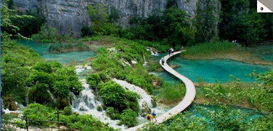
The word "Meghalaya" literally means "The Abode of Clouds" in Sanskrit and other Indic languages. We can visit to many of famous waterfalls, Wildlife viewing, Cave viewing, Water sports, Trekking, Angling, Playing golf, Lake viewing, Nature walk in many of its hillocks.Meghalaya is also known as the "Meghalaya Plateau". It consists mainly of archean rock formations. These rock formations contain rich deposits of valuable minerals like coal, limestone, uranium and sillimanite. Meghalaya has many rivers. Most of these are rainfed and are therefore seasonal. The important rivers in the Garo Hills Region are Daring, Sanda, Bandra, Bhogai, Dareng, Simsang, Nitai and the Bhupai. In the central and eastern section of the plateau, the important rivers are Umkhri, Digaru, Umiam, Kynchiang (Jadukata), Mawpa, Umiew or Barapani, Myngot and Myntdu. In the southern Khasi Hills Region, these rivers have created deep gorges and several beautiful waterfalls.Meghalaya has some of the thickest surviving forests in the country and therefore constitutes one of the most important ecotourism circuits in the country today. The Meghalayan subtropical forests support a vast variety of flora and fauna. Meghalaya has 2 National Parks and 3 Wildlife Sanctuaries.Meghalaya has an estimated 500 natural limestone and sandstone caves spread over the entire state including most of the longest and deepest caves in the sub-continent. Krem Liat Prah is the longest cave and Synrang Pamiang is the deepest cave, both located in the Jaintia Hills.
Eco places in Meghalaya
All three of the hills of Meghalaya - Khasi, Jaintia and Garo are blessed with abundance of natural heritage, and have plenteous sightseeing Eco places. There are many of waterfalls like Bishop and Beadon Falls, Sweet Falls, Elephant Falls, Spread Eagle Falls and Lmilchang Dare Falls, which are very scenic, and are flocked by heaps of nature lovers. Exploring many of the tranquil lakes, and caves like Syndai and Siju is a very lucrative invitation to nature lovers. Either it is nature walk on numerous of its hillocks located at popular peaks like Shillong peak and Tura peak or it is jungle viewing at Botanical garden and Balpakram Wildlife National Park, Meghalaya is full of Eco excursion. Many of the beautiful peaks and serene lakes mostly act as favourite hang out and picnic spot.
 |
| Garo hills |
Khasi hills :
The Khasi Hills are part of the Garo-Khasi range in the Indian state of Meghalaya.The region is inhabited mainly by tribal Khasi dwellers, which are traditionally in various chieftainships, petty states known as the Khasi Hill . Shillong Peak, Sohpetbneng Peak, Ward's Lake, Umiam Water Sports Complex, Golf Course, Bishop and Beadon Falls, Sweet Falls, Elephant Falls, Spread Eagle Falls, Diengieipeak, Kyllang Rock, Cherrapunjee, Ranikor, Nongkhnum Islands.
Garo hills :
Garo hills :
Nokrek biosphere, Tura Peaks, Williamnagar, Sisbibra, Resubalpara, Napak, Baghmara, Nengkong, Siju Caves, Balpakram National Wildlife Park. Chidimak-Chianggal (Black Water), Goncho Dare, Wakso Chiring, Bandini Nagil.
Jaintia hills :
Jaintia Hills boasts of exquisite natural beauty. Few of the places of interest in Jaintia hills are Jowai, Syndai, Thadlaskein Lake, Syntu Ksair, Nartiang.
 |
| cherrapunji |
Cherrapunj is a town in East Khasi Hills district in the Indian state ofMeghalaya. It is credited as being the wettest place on Earth.The cliffs of Cherrapunji receive heavy rainfall due to monsoon winds blowing from the Bay of Bengal. Thus, the region is home to extremely wet weather.
Cherrapunji's yearly rainfall average stands at 11,777 millimetres (463.7 in).[3] This figure places it behind only nearby Mawsynram, Meghalaya, whose average is 11,873 millimetres (467.4 in). Cherrapunji receives both the Southwest and Northeast monsoon showers which give it a single monsoon season. It lies in the windward side of the Khasi Hills. Orographic precipitation results, and monsoon winds are forced to deposit much of their moisture. In the winter months it receives the northeast monsoon showers which travel down the Brahmaputra valley.
Cherrapunji's yearly rainfall average stands at 11,777 millimetres (463.7 in).[3] This figure places it behind only nearby Mawsynram, Meghalaya, whose average is 11,873 millimetres (467.4 in). Cherrapunji receives both the Southwest and Northeast monsoon showers which give it a single monsoon season. It lies in the windward side of the Khasi Hills. Orographic precipitation results, and monsoon winds are forced to deposit much of their moisture. In the winter months it receives the northeast monsoon showers which travel down the Brahmaputra valley.
 |
| Nohkalikai Falls |
Nohkalikai :
Nohkalikai Falls is one of the tallest waterfalls in India.Nohkalikai Falls are fed by the rainwater collected on the summit of comparatively small plateau and decrease in power during the dry season in December - February.Name of the falls (in Khasi language - "Jump of Ka Likai") is linked to a legend about local women Likai who after family tragedy became insane and jumped off the cliff next to the falls
Reaching there
By Air : Though Shillong has its own airport at Umroi, but it has limited 6 flight in a week, that too only to Kolkata. Thus, Guwahati (128 km) still acts as nearest airport of Shillong (capital of Meghalaya). Guwahati has daily flight to metropolitan and international airport like Delhi and Kolkata. Even there are helicopter service between Shillong and Guwahati, which takes approx 30 minutes to reach.
By Rail : Guwahati is the nearest major railway station from Meghalaya. Guwahati is linked with main rail lines, and has luxury trains like Rajdhani express for New Delhi railway station. After reaching Guwahati, one needs to catch bus for Guwahati, which takes approx 3 hours to reach. Even one can hire taxi from Guwahati to Shillong, costing around Rs.1200-1400.
By Rail : Guwahati is the nearest major railway station from Meghalaya. Guwahati is linked with main rail lines, and has luxury trains like Rajdhani express for New Delhi railway station. After reaching Guwahati, one needs to catch bus for Guwahati, which takes approx 3 hours to reach. Even one can hire taxi from Guwahati to Shillong, costing around Rs.1200-1400.
By Road : Meghalaya is a land locked state with a large number of small settlements in remote areas. Road is the only means of transport within the state. While the capital Shillong is relatively well connected, road connectivity in most other parts of the state is relatively poor. A significant portion of the roads in the state are still un-metalled. Most of the arrivals into the Meghalaya take place through Guwahati in neighboring Assam, which is nearly 103 km away
Thanks for sharing the post! Really such nice and good information shared here with awesome stuff. Pics are beautiful. See more information about How to Reach ur destination.
ReplyDelete